GLOBAL > WAC Charts
WAC Charts
Revolutionizing WAC Chart Production for Safer Air Navigation
The World Aeronautical Chart (WAC) is primarily used for visual air navigation over large areas. It provides essential information for planning general aviation transit flights, such as geographical and topographical landmarks, obstacles, aerodromes, navigational aids, and restricted areas.
In accordance with the requirements of the International Civil Aviation Organization (ICAO), each country is responsible for the production and updating of WAC charts, adhering to the standards defined in Annex 4 (Aeronautical Charts) and Annex 15 (Aeronautical Information Services). These requirements are regularly monitored by ICAO through audits aimed at ensuring the compliance and safety of the published information.
In this context, CGX has implemented innovative and tailored solutions to simplify and optimize the production and updating of WAC charts, addressing the technical and organizational challenges faced by aviation authorities.

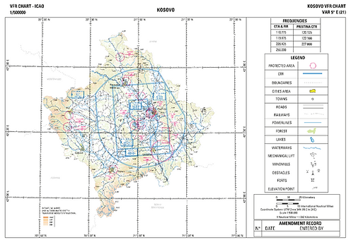
Kosovo VFR Chart
Challenges and Strategic Goals in WAC Chart Production
The Strategic Objectives of WAC Charts
In compliance with ICAO Annex 4, WAC charts are essential for visual air navigation. They facilitate flight planning and enhance pilot situational awareness by providing a comprehensive overview of aeronautical and geographical constraints within a given territory. They also serve as a foundational layer for other types of aeronautical charts.
To ensure their relevance and effectiveness, these charts must meet several criteria. They must incorporate accurate and reliable aeronautical and topographic data, while being updated in accordance with ICAO standards. The output format must be compatible with both digital and print uses (PDF, GeoPDF, GeoJSON, GeoTIFF) to accommodate different consultation and usage modes. Moreover, thanks to recent technological advancements, their distribution can now be optimized via web streaming services (WFS/WMS) and integrable GeoJSON layers, offering customized layouts tailored to national specifications and the requirements outlined in ICAO Annex 4, Appendix 5.
Technical and Organizational Challenges in WAC Chart Productionnd Validation
Despite their critical importance, the production and updating of WAC charts are often hindered by several challenges:
Heaviness Chart Initialization: Creating WAC charts requires significant preparatory work. This involves collecting and harmonizing geographical and aeronautical data on a national scale, a process that can be time-consuming and resource-intensive. Each chart must be meticulously developed in compliance with ICAO standards, with careful attention to topography, obstacles, and international boundaries.
Limited Update Frequency: Although WAC charts are essential tools, their update cycle (once or twice a year) is limited, posing a major challenge in terms of responsiveness. As a result, the data can quickly become outdated—particularly regarding new obstacles or changes in airways—representing a potential safety risk.
Complexity of Borders and Boundary Areas: Managing data across neighboring countries can lead to discrepancies, complicating harmonization efforts.
Data Quality and Integrity: Identifying relevant data sources, particularly for topographic information, is a major challenge.
Information Completeness: Ensuring full and consistent coverage, especially in areas with low data density, remains problematic.
Obstacle Updates: Managing and updating obstacles (buildings, terrain, antennas) is complex and requires regular updates.
Large Data Volume: Integrating aeronautical and topographic data to generate charts is a heavy and time-consuming task.
Resource Mobilization: Producing WAC charts demands significant human resources, often at the expense of other strategic tasks such as updating IAC, SID, or STAR charts.
Skill Retention: The low frequency of WAC chart updates can lead to a loss of expertise, making their production increasingly difficult over time.
In response to these complex challenges and the growing demands of civil aviation, CGX AERO has developed a methodical approach and specialized tools to address the urgent needs of aviation authorities.
CGX AERO’s Methodology for Optimized WAC Chart Production
The production of WAC charts relies on rigorous management of aeronautical and topographic data. To meet the requirements of aviation authorities and ensure compliance with ICAO standards, it is essential to have an appropriate methodology and specialized tools.
CGX AERO supports its clients in this process by offering a comprehensive solution that integrates data structuring, automated chart production, and centralized update management.
Optimized Data Management
One of the main challenges in producing WAC charts can be found in managing source data, which often comes from multiple reference frames and requires prior harmonization. CGX AERO intervenes at several levels to structure this information:
-
Assessment of Available Data: Identifying and analyzing existing data sources to ensure their reliability and suitability for WAC chart production.
-
Data Processing and Conversion: Integrating aeronautical data (AIXM) and topographic data (Shapefiles, GeoJSON, GeoTIFF) into a format that can be used for chart production.
-
Completion of Missing Data: Structuring and generating aeronautical and topographic data when essential information is not available.

integration of roads and city contours with airport data
Data integration is a fundamental and critical step even before the chart production process begins. Often, the variety of data formats and/or the lack of aeronautical data in AIXM format delays production and wastes valuable time.
CGX AERO provides a concrete solution to these data management challenges through its Data4Flight® software — a centralized database built on PostgreSQL that ensures the storage and management of topographic and aeronautical data. It is compatible with major GIS platforms (ArcGIS, QGIS, Global Mapper), ensuring seamless integration into existing workflows, and supports a wide range of data formats.
Tools Designed to Facilitate the Production and Updating of Charts
CGX AERO offers tailored solutions to simplify the production of WAC charts, notably through the AIP-GIS Charting® software, a specialized GIS that automates chart production according to ICAO standards, optimizing several steps in the process:
-
Automated Layout: Charts are generated by automatically applying graphic representation rules, ensuring consistency and compliance with the requirements of ICAO Annex 4 and DOC 8697.
-
Selection and Display of Relevant Data: Using advanced filters, the tool extracts the necessary information based on the specific needs of each chart.
-
Application of Symbols and Annotations: Cartographic conventions are automatically integrated, avoiding lengthy manual operations and reducing the risk of errors.
-
Customization and Adaptation to User Needs: The software allows layout adjustments based on local constraints, whether it be sheet size, adding specific elements, or overlaying additional information layers.
Secure Access and Chart Distribution
WAC charts must be easily accessible to relevant stakeholders while respecting security and validation constraints. CGX AERO provides various solutions to ensure controlled distribution:
-
Secure Web Portal: Online access to charts for consultation and download.
-
Secure Exchange Platform: Availability of raw and finalized data within a protected environment.
-
Publication in Compliance with AIP Requirements: Integration of charts into aeronautical production workflows to ensure their compliance and accessibility.
An illustrative example of this approach is the AIM portal developed by CGX AERO for Croatia. This secure and high-performance online platform enables the dissemination of aeronautical information products such as the eAIP, aeronautical charts, and the VFR manual. Reserved for registered users, these resources are fully suited for operational use. The system ensures complete data integrity—products are made available in their original form, with no alteration after creation. Integrity is rigorously preserved during storage and throughout transmission via the Internet, guaranteeing reliable and trusted access for all users.


Tailored Support for the Needs of Aviation Authorities
To address the diverse needs of aviation authorities, CGX AERO offers several support options to ensure an optimal solution for the production and updating of WAC charts.
Autonomous In-House Production: In this model, clients take full responsibility for the production and updating of WAC charts using the tools and methodology provided by CGX AERO. Personalized support and thorough training enable teams to manage the process independently while ensuring compliance with international standards.
Gradual Skills Transfer: CGX AERO assists the client during the initial stages of chart production and updating before progressively transferring the necessary skills for autonomous management. This solution combines CGX AERO’s expertise with the client’s gradual acquisition of independence for long-term WAC chart management.
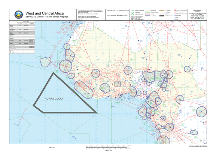
A concrete example of this approach was carried out with ASECNA. Based on data provided by the agency, CGX AERO produced an en-route chart covering the entire airspace under its management, using a methodology closely aligned with that of WAC chart production. Although designed for en-route navigation, this type of chart shares many similarities with WAC charts in terms of scale, topographic content, and aeronautical representation. The chart shown below illustrates the western portion of this work. This project demonstrates CGX AERO’s ability to support aeronautical authorities in the production of complex charts, ensuring compliance with ICAO standards while adapting to regional specificities.

Complete Outsourcing of Production and Maintenance: For clients wishing to focus on their strategic priorities, CGX AERO offers to fully handle the production and updating of WAC charts. This ensures smooth, fast, and compliant chart management with full support from a trusted partner.
Each of these options provides maximum flexibility to meet clients’ specific needs. Whether through autonomous management, progressive skills transfer, or full outsourcing, CGX AERO offers an innovative and efficient approach that not only simplifies WAC chart production but also guarantees their rapid and compliant updating according to international requirements, thereby contributing to the safety and efficiency of global air navigation.